A brief report on GPS land Mapping-Homestead and NRM plots
Chief is the sole owner of land in Kuki Society. Land Tenure Security through proper documentation is one of the biggest challenges in the Kuki society as there is no legal documentation or records maintained. This kind of land tenure system has been practiced only through the mutual understanding, oral or verbal system. Villagers are carrying out the cultivation of land at the mercy of the Chief. Outsiders, which refers to people from other villages, are permitted to carry out cultivation by either paying tax or in kind, usually a part of the produce. As a consequence, the villagers feel discouraged to undertake long-term land use or cultivation despite their willingness. As a result, they are engaging in short-term crops cultivation.
For a long time, the poor and landless farmers of the targeted villages have been neglected. Moreover, they do not have access to schemes & benefits that are provided by various government departments. This is happening because most farmers are landless and do not possess any documents related to land. Only a few poor farmers have been able to gain access to MGNREGs (Mahatma Gandhi National Rural Employment Guarantee Scheme), PM KISAN (Pradhan Mantri Kisan Samman Nidhi), and NFSA (National Food Security Act). However, they have low access to PMAY (Pradhan Mantri Awas Yojana) schemes, credit linkages from Banks, housing loans and schemes, and application of other Agricultural allied sectors, as they do not possess the land records.
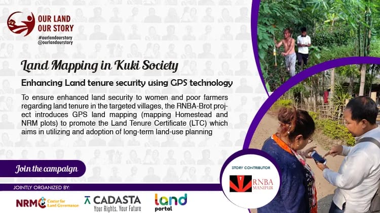
To ensure enhanced land security to women and poor farmers regarding land tenure in the targeted villages, the RNBA-Brot project introduces GPS land mapping (mapping Homestead and NRM plots) to promote the Land Tenure Certificate (LTC) which aims in utilizing and adoption of long-term land-use planning and also accessing schemes & benefits to the most deserving beneficiaries of the villages.
To carry out mapping, we firstly have a community meeting where village authority (V/A), women, men, and youth participate. Next through the meeting, we draw a village map, identify any plantation, homestead, and NRM (Natural Resource Management) plots to be mapped, identify youth to participate in mapping, help the villagers to download apps, and get the villagers ready for collecting information through questionnaires. This is followed by mapping homestead and NRM plots of the villages.
The challenges faced are highlighted as follows –
Few of the villagers do not have an Aadhaar card, bank account, or voter ID card to prove that they are residents of the villages. It is so because they continuously migrate from one village to another, and their identity cards have not yet changed to their present residents.
Some of the villagers were not willing to wait for their turn for mapping. It is so because the villagers think that they will not get any benefits from it as the land will still be under the control of the Chief.
The Chief also did not encourage the process of mapping land for the poor farmers, as he feels that the poor villagers are not planning to settle permanently in the village.
The poor farmers feel that it is difficult to approach the government offices and hence do not spare much time pursuing schemes & benefits.
Achievements:
- Through the introduction of Land Mapping for issuing Land Tenure Certificate (LTC), the chief become more open to the idea of villagers having long-term land use or cultivation.
- Most poor farmers are willing to have a Land Tenure Certificate (LTC).
- The poor farmers plan to promote long-term land cultivation via the introduction of GPS land mapping and LTC.
- The targeted villages are also willing to carry out mapping in their villages.
- It is expected that LTC will increase the access to the villagers of the various schemes & benefits of different line government departments.
Story Contributor: